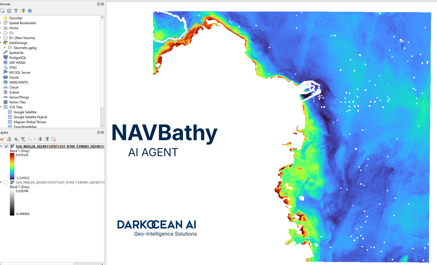
Darkocean today announced NAVBathy, an AI-driven marine mapping agent that produces large-scale relative bathymetry in seconds using low-resolution satellite imagery.
DOHA, QATAR, November 16, 2025 /24-7PressRelease/ — Darkocean today announced NAVBathy, an AI-driven marine mapping agent that produces large-scale relative bathymetry in seconds using low-resolution satellite imagery. Early results demonstrate NAVBathy’s capability to cover roughly 70% of Qatar’s coastline and map nearly 100 kilometers of adjacent marine areas, delivering fast, actionable depth information for project planning and risk reduction.
NAVBathy scouts suitable satellite imagery and generates consistent relative depth models at speeds and scales not previously achievable with traditional surveying methods. The system provides planners, engineers, and marine operators with immediate situational awareness of seabed conditions, enabling better-informed decisions during early project phases and helping to avoid costly surprises during execution. By focusing on relative bathymetry, NAVBathy complements, rather than replaces, high-precision hydrographic surveys, offering a rapid screening layer that highlights areas requiring detailed follow-up.
“The ability to generate accurate, large-scale relative depth maps within seconds transforms how coastal projects are scoped and risk-assessed,” said Neha Supekar, AI Solution Architect at Darkocean. “NAVBathy gives teams an instant, evidence-based view of underwater terrain so they can prioritize detailed surveys, optimize logistics, and reduce schedule risk — especially in regions where traditional survey resources are limited.”
NAVBathy’s approach relies on advanced machine learning models trained to interpret data and signals from low-resolution satellite data to infer relative seabed depth across wide areas. In the Qatar demonstration, within few seconds, NAVBathy successfully mapped extensive shoreline stretches and nearshore zones, providing a clear operational picture across channels, shoals, and shallow shelves. The product is designed to integrate with existing GIS and marine planning tools, offering exportable layers, time-series comparisons, and change detection to support environmental monitoring, dredging planning, coastal development, and emergency response.
Darkocean emphasizes that NAVBathy should be used as an early-stage planning and reconnaissance tool. For projects requiring precise absolute depths for navigation or regulatory compliance, targeted in-situ hydrographic surveys remain essential. NAVBathy helps reduce the footprint and cost of those surveys by focusing resources where detailed measurement is most needed.
About Darkocean
Darkocean is a marine geospatial technology company developing AI-powered solutions that accelerate safe and sustainable ocean development. The company combines satellite analytics, machine learning, and domain expertise to deliver fast, scalable insights for coastal planners, maritime operators, and environmental managers.
The company’s portfolio includes autonomous survey platforms, real-time remote operations, and AI agents designed for rapid data processing, QA/QC automation and large-scale environmental intelligence. Leveraging senior expertise from global marine leaders and a distributed engineering footprint across Qatar, UAE, KSA, the UK and India, Darkocean delivers mission-critical data for national infrastructure, energy transition, subsea engineering, and coastal resilience projects.
Website: https://www.darkocean.biz
Media Contact
Kanak Jadwani
Head of Communications, Darkocean
kjadwani@darkocean.biz
+974 44426003
—
For the original version of this press release, please visit 24-7PressRelease.com here
Legal Disclaimer: This article was provided by an independent third-party content provider. Kyrion Media makes no warranties or representations in connection with it. All information is provided “as is” without warranty of any kind. This content may not have been reviewed by our editorial staff and is published automatically. The views expressed in this article are those of the author and do not necessarily reflect the views of Kyrion Media. All trademarks are the property of their respective owners. If you are affiliated with this article and would like it removed, please contact retract@kyrionmedia.com.